Very often, in every community, someone wants to build an accessory structure. How can we help them do it without armoring a riverbank (now or in the future), displacing floodwaters, and putting neighbors and roads at risk? We’ve included a few tools to help you evaluate these structures.
This page has guidance on what accessory structures need to be floodsafe, including an introduction to the basic things you should consider, determining if the proposed building site is located in a River Corridor or Special Flood Hazard Area, and what to do if you know it's in the River Corridor or the Special Flood Hazard Area.

The Basics
Anytime someone wants to build something in a River Corridor (RC) or the Special Flood Hazard Area (SFHA), it deserves careful evaluation to make sure it won’t put other roads, buildings, and people downstream at risk. This no adverse impact strategy ensures that one landowner’s choices don’t increase the risks for others’ property and wellbeing.
What Is an Accessory Structure?
An accessory structure is pretty much any building that isn’t a place where someone would live or work; typically a storage shed or a garage. It could be attached to a home or standing on its own. If the structure is built as a living space, it’s a residence or an accessory dwelling. We don’t cover that review process here but all of the review standards for an accessory structure could apply to a dwelling, along with additional specific requirements. Also, if the structure is for agricultural use, or is part of an existing Act 250 permitted project, it needs to both comply with local regulations and State rules. Your local regulations may generally exempt some structures like small sheds from review, but these exemptions do not apply in a flood zone.
Use Your Municipal Regulations
To evaluate building proposals in your community, use your community hazard and zoning regulations. This guide goes into details related to rivers, streams, and flooding, so there may be additional local requirements that aren’t covered here that you still need to apply to a proposal. Your regulations also may not include all of the details below. While accessory structures need to meet your regulations, any topics below that aren’t included in your regulations may still be useful guidance for the applicant to build something safe, even if it isn’t required.
If your community hasn’t adopted a River Corridor protection bylaw, consider adopting the model bylaw to make your community safer and qualify for greater Emergency Relief and Assistance Funding (ERAF). You might also want to review your regulations for development in the SFHA and see if they could be more in line with model regulations. Adopting these bylaws and regulations is important to protect your roads, residents, and the ability for your first responders to reach all areas of your town during a flooding disaster. But it’s also a smart legal plan. If a resident can clearly demonstrate that a neighbor’s building project was responsible for the flood damage they incurred, that neighbor or the town may be liable for causing the problem.
Avoid Surprises
The worst case scenario in this process is that you find out about the new accessory structure after it’s already been built. Ideally, you can have a conversation with the applicant before they’ve invested any money in site plans, materials, or building. Some residents may not realize they need to talk with the town to begin or they may not want to. It’s important to let residents know that they need to apply for permits at the very beginning of the process. Review the Getting The Word Out component of this module for communication ideas and templates. To remind community members about the process, consider posting a reminder to Front Porch Forum and local newspapers every spring as people are thinking about starting new projects. You could also use the guide below to help applicants put together details on their structure that you’ll need for your review and leave copies at the Clerk’s office to hand out.
One of the most important things to ensuring these conversations happen early is to be accessible. Make sure your email and phone number are on the town website or is on a card at the Clerk’s office. Consider any way you can encourage people to start the conversation at the beginning rather than well into the project.
Get Help
Your Regional Floodplain Manager is here for you. We want to help you ensure that all development in or near River Corridors and floodplains has no adverse impact on the rest of your community. If you have any questions about how to evaluate something, contact us. The new DEC model bylaws also provide language to support "no adverse impact" outcomes that allow for specific kinds of infill development in River Corridors and floodplains. Such standards can avoid both sprawl as well as making the hazard worse.
Is It in the River Corridor or the Floodplain?
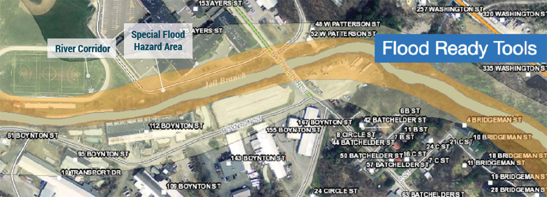
The first step is to determine if the structure is proposed within the River Corridor (RC), the Special Flood Hazard Area (SFHA), or anywhere specifically regulated by your community. Start with the ANR Flood Atlas. The RC for the entire state is available here, using these steps:
-
Click the Flood Ready Tools button once the Atlas loads.
-
Click the Find Address option and type in the address. Select the matching address to zoom to the location. If the address isn’t available, you can manually zoom to the location.
-
Click the Flood Ready Tools button again and click the “Toggle Flood Data On” and the “Toggle River Corridors On” links. The RC displays as a light yellow. The SFHA displays as red or orange (and if you don’t see it at a river, read below). If the location is within one of these layers, you’ll need to apply regulations appropriate for that area.
What If Layers Don’t Display?
You may need to wait a minute for the layers to load or zoom in further. Small streams will have a dotted yellow line. The RC for these streams is measured as fifty feet from the top of the stream bank.
Much of Vermont’s SFHA has not been digitized and will not be available in the Atlas. If this is the case for your community, you’ll need to use FEMA maps that may be found on the FEMA website or on paper in your town office. See the component of this training for using old maps to determine whether or not the structure will be in the SFHA.
Could the Zones Be Wrong?
Yes! Maps could have errors and can be refined to meet local realities. Contact your Regional Floodplain Manager to discuss any amendments to the RC you feel may be necessary. If the surveyed base flood elevation (BFE) is contrary to the maps, the property owner may apply to FEMA for a Letter of Map Amendment (LOMA).
Structures Proposed for the River Corridor
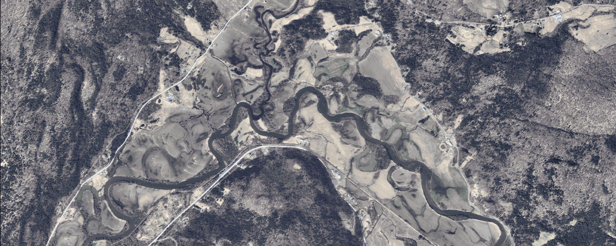
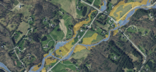
Rivers change paths, sometimes over decades, sometimes in a day during a storm. The RC is the area that the river may eventually move. See how the path of the Lamoille river above has changed over the years. Learn more about them on the Flood Ready site. Building in the RC is problematic because the river may eventually move toward the building, eroding the ground underneath it and destabilizing its foundation or washing it away, creating dangerous debris during a flood.
To protect the building, landowners traditionally reinforce the riverbank or streambank, reducing the likelihood that the river could move toward it. Unfortunately, this kind of bank armoring increases the speed of the water by blocking the river from finding the slowest way down the valley. Higher water speed increases erosion and danger downstream. All of these changes can put roads, bridges, and buildings that were previously safe at risk of damage.
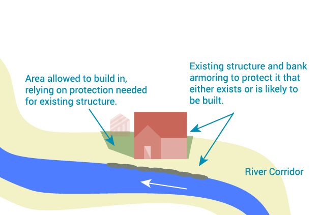
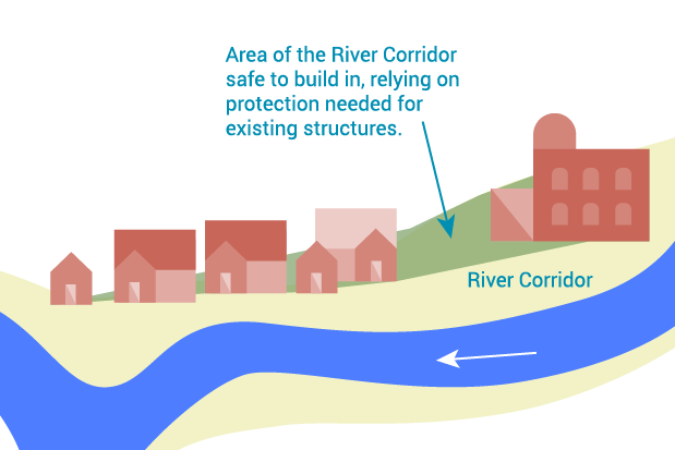 Where Can We Build in the River Corridor?
Ideally, we wouldn’t build anything within the RC, especially valuable structures like homes. But a complete halt to all development within the RC isn’t always feasible for communities. If you must develop something, do it in a way that won’t require additional bank armoring.
Here’s what that could look like. If a home already exists in the RC, it’s reasonable to assume that the homeowner will protect it by reinforcing banks. As long as that protection would also protect the location of the accessory structure, that is a safer place to build. If, however, the location of the proposed structure would require extending the bank protection further to also protect it, it’s not an appropriate location. In general, nothing should ever be built in the RC closer to the river or stream than an existing home. If an applicant believes that the site location should not be in the RC because some geological features may prevent the river from moving to that location in the future, connect them with your Regional Floodplain Manager to set up a site visit and discuss an amendment to the RC.
Structures Proposed for the Special Flood Hazard Area
Building in the SFHA should stay out of the Floodway and it needs to meet the standards for the flood zone. FEMA provides extensive details for building in the floodplain, and communities need to follow these guidelines as part of their commitment to participate in the National Flood Insurance Program (NFIP), which allows any resident to purchase insurance. All development projects within the SFHA require a permit that indicates the proposal complies with NFIP. Before that permit is issued, the proposal needs to be reviewed by the Regional Floodplain Manager. This section covers the basic information you’ll want to consider for accessory structures. Keep in mind that your community may have adopted stronger regulations than what the NFIP requires. Consider adapting your own guide by integrating any local regulations with the Accessory Structure Application Review Checklist.
Don’t Build in the Floodway
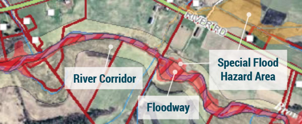
A "Regulatory Floodway" means the channel of a river or other watercourse and the adjacent land areas that must be reserved in order to discharge the base flood without cumulatively increasing the water surface elevation more than one foot.
Determining Base Flood Elevation
You need to determine the base flood elevation (BFE): how high the water is likely to rise during a 100 year flood. The Flood Insurance Rate Maps (FIRM) provided by the NFIP will help. Where the FIRM does not provide a BFE (i.e. Zone A), the applicant will need to determine the elevation with help from a surveyor or their Regional Floodplain Manager. If the location is safely above the flood level, the applicant may apply to FEMA for a Letter of Map Amendment (LOMA), indicating it is not in the SFHA. If the location is below flood level, appropriate measures must be used as described below. You can learn more about determining Base Flood Elevation in the Working with Zone A Maps and Determining Base Flood Elevation component of this training module.
No Fill / No Net Fill
To have no adverse impact, you can’t add fill and increase the flood level. The new structure should be placed so as to not displace floodwater. That means no new fill to level or raise the building site or to bring a road or path to the building. Displaced/redirected water has to go somewhere and any new fill added to build this structure will raise the flood level elsewhere, which can put other roads, bridges, and buildings at risk.
In some cases, the applicant may be able to add fill if an equivalent amount of fill is removed from a location close enough to absorb the floodwater that will be displaced by the new fill.
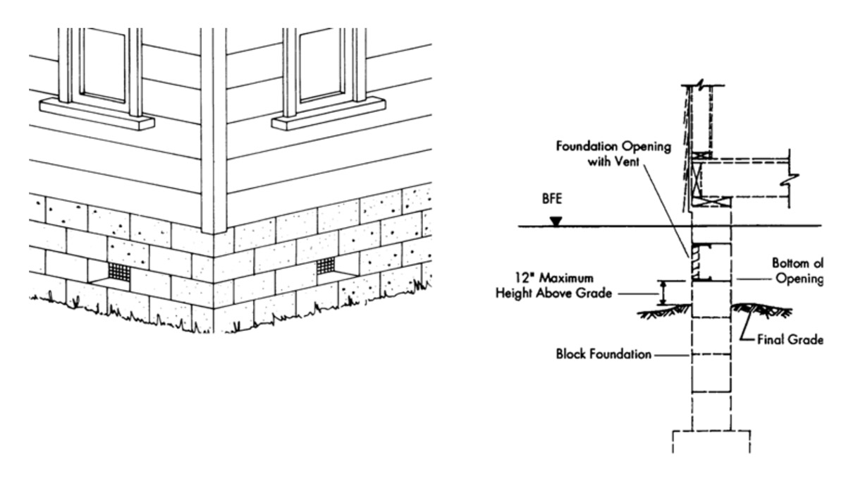
Flood Vents
Water must be allowed to move into any part of the building that is below BFE during a flood to ensure that pressure remains equal, avoiding collapse. If the space below BFE is enclosed, such as a crawl space, or an elevated area dedicated to parking, designs for meeting this requirement must either be certified by a registered professional engineer or architect or meet or exceed the following minimum criteria:
- Provide at least two openings with a total net area of at least one square inch for every square foot of enclosed area subject to flooding. For example, if the area of the enclosure is 1,000 square feet, the area of the openings combined must total at least 1,000 square inches. Keep in mind that if a grating or vent cover is used, the net opening area must be used for this calculation.
- Install the openings on at least two walls to ensure they will work in case one gets blocked.
- The bottom of all openings must be less than one foot above grade. They may be equipped with screens, louvers, valves, or other coverings but must permit floodwater to flow in and out.
Anchoring
The structure must be anchored securely to a permanent foundation so that water can pass in and out without moving it through collapse, force of rushing water, or floatation. You may require the applicant’s architect or engineer sign a statement saying that the design of the building includes “anchoring adequate to prevent flotation, collapse and lateral movement” during the base flood.
Flood Resistant Materials
All parts of the building that could be exposed to floodwaters should be made of flood resistant materials that can withstand floodwater contact for at least 72 hours and require only low-cost cosmetic repair (such as painting) to fix. While NFIP requires the use of these materials up to the BFE, Vermont recommends using them up to two feet above the BFE. A list of appropriate materials can be found on page 5-44 of the NFIP Floodplain Management Requirements. These are materials like concrete, ceramic tiles, galvanized or stainless steel, indoor-outdoor carpeting, vinyl, stone and slate, pressure treated or naturally decay resistant lumber, and marine grade plywood. Materials like particle board or standard plywood would not be flood resistant.
Utilities
All utilities, including fuel tanks, electrical boxes, switches, and outlets, should be securely mounted/stored above the BFE (ideally two feet above). Only the minimum amount of electrical equipment required by code may be located below the BFE, and that equipment must be flood damage resistant/submersible. And even that should be replaced if it gets flooded. For additional guidance, see FEMA’s guide to Wet Floodproofing Requirements or FEMA’s publication on Protecting Building Utilities from Flood Damage.
Resources

Reflection Questions
- What do your municipal regulations say about building accessory structures within a River Corridor or Special Flood Hazard Area? Do they need to be updated?
- How can you increase the likelihood that your residents will discuss their building ideas with you at the very beginning of the process?
- Where is the best place to find SFHA data for your town or city?
- How can you customize the questionnaire and the checklist to help residents build safely?