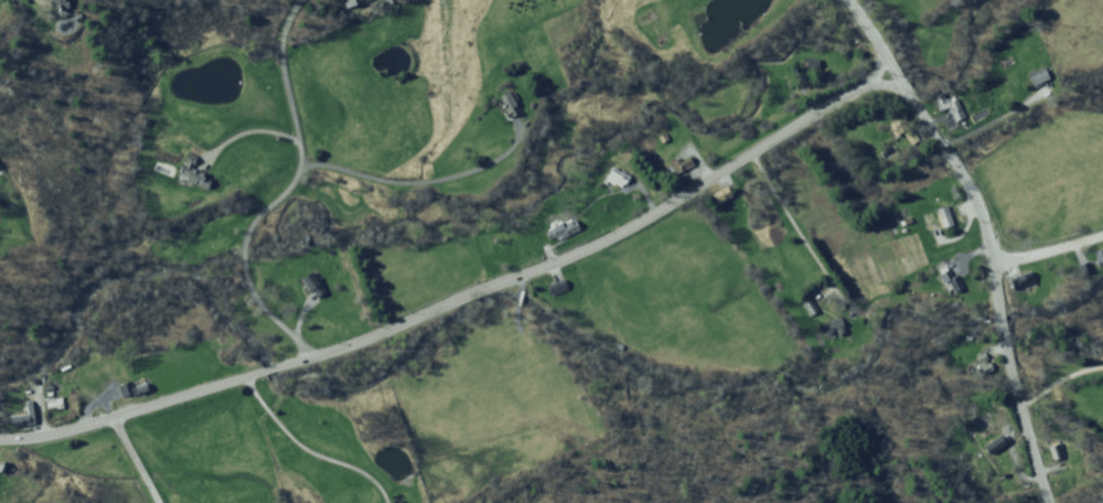
Your house has never flooded, but during four days of rain last year with some pretty spectacular storms, you grew concerned when the stream across the road rose over its bank and came within fifteen feet of your front porch. Your house isn’t in the floodplain—at least not according to the FEMA maps at the town office—and you’ve never purchased flood insurance. Now, however, you've learned about plans for a new house being built up the road where you saw standing water during that same stretch of rain. Apparently, they’re going to raise the land so the house is well out of flood risk. What might this mean for your house during the next storm?
 This happens. People add some fill or reinforce a stream bank and unintentionally raise the risk of flood damage for their neighbors or roads and bridges. To protect people and town budgets, Select Boards across Vermont are adopting bylaws that ensure floodplains and river corridors can function when we need them. This natural infrastructure allows water to find its slowest, safest way through your town. The more frequent and intense rainstorms headed our way as a result of our warming climate make these natural assets even more critical.
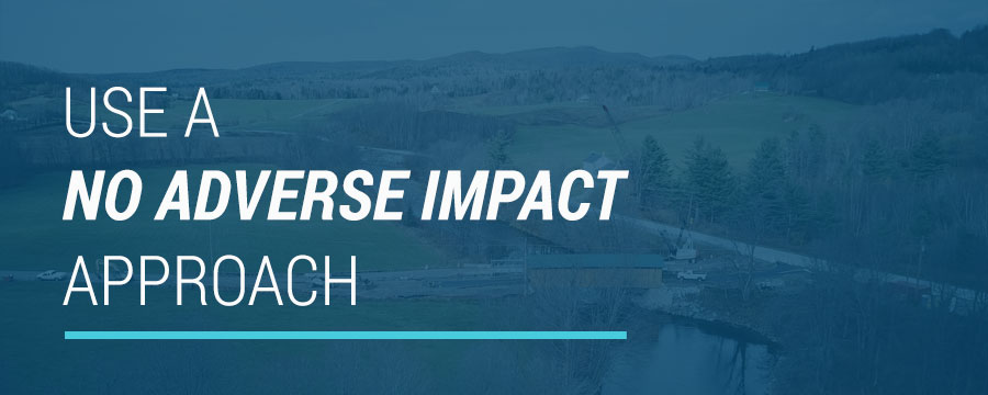
Over one third of Vermont towns (as of early 2022) have already adopted bylaws to ensure new development within their floodplains and river corridors will not adversely impact existing assets, like buildings, roads, or bridges. Use this page to explore how you can protect your community with a No Adverse Impact approach.
Sections on this page:
- This Is a Town Responsibility
- Protect What Has Already Been Built With Your Bylaws
- Tell Citizens About Your New Bylaws

This Is a Town Responsibility
Federal, state, and local governments are all involved in mitigating losses from flooding. For the most part, federal and state initiatives support safer development through incentives and technical assistance for municipalities … this website, for instance. While Vermont does regulate some larger developments, most of the power protecting the health, safety, and welfare of people is given to municipalities through Chapter 117 of the Vermont Planning and Development Act. If you represent a municipality, you are responsible for planning and regulating land and water to keep people and investments safe.
Financial Liability
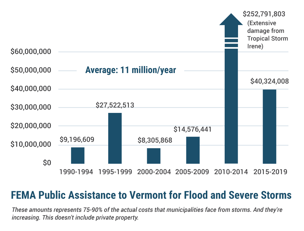
Flood damage is really expensive. Over the last two decades, almost every Vermont town has requested financial assistance (often multiple times – see the map) after flooding. This assistance is only available when a disaster is declared, leaving towns sometimes holding the full cost of repairs. After a flood, towns might suddenly need to come up with tens of thousands of dollars or even over a million dollars for repairs. The town of Groton, for example, received $686,000 of federal funds between 2004-2011 for 49 projects to repair public infrastructure damaged by storms. That means the town was likely responsible for paying roughly $100,000, which is 3-4% of the taxes they collected over the same period.
Of course, residents who already live in floodplains and river corridors also face significant financial (and safety!) risk. These often include our most vulnerable neighbors who have the least resources to purchase flood insurance or relocate to safer areas. About 7% of Vermont homes are mobile homes, but they were 40% of the homes damaged during Tropical Storm Irene. And FEMA’s own analysis shows that simply having a low income will make it less likely that you receive federal disaster relief.
Bylaws that protect the functions of river corridors and floodplains keep our roads from washing out and protect residents who can’t afford a loss. They’re equitable.
Legal Liability
With the responsibility to keep people and investments safe comes legal liability. In the event of life or property loss, is a municipality liable for allowing changes to the landscape that increased flood risk? Each situation is unique, but there is clear support in case law for municipalities regulating land use to reduce risk of loss. The liability for failing to do so is likely greater than any liability for restricting what a property owner can do with their land. Read this Vermont Law School publication for more detail on legal responsibilities.
Your Decisions Last Lifetimes
 Our current risk of flooding is often related to development decisions that were made over the last 300+ years in the absence of any plans to protect the community. A small amount of fill and some river bank armoring here and there may not feel like much at the moment; but over decades, those choices compound. Future generations will live with the decisions we make today. We know that our changing climate will bring more intense storms and flood damage. We know that our most vulnerable neighbors often live on land that is at greater risk of flooding. How do you want to support your community going forward?

Protect What Has Already Been Built With Your Bylaws
Changing How We Live With Rivers
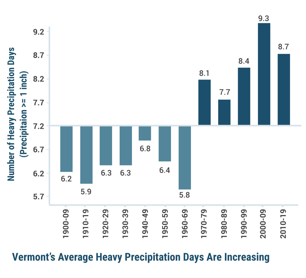
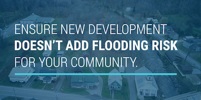
When we realized that draining sewage into streams, putting lead in our paint and gasoline, and feeding the bears increased risk for the community (and the bears), we changed. Similarly, we need to rethink how we live with streams and rivers. Every time we fill in a floodplain, armor a riverbank, or straighten a stream, preventing it from finding the slowest path through your town, we may increase risk of damage to property and people. Even when there are no other buildings or roads within miles, a smaller floodplain means less capacity to slow and hold water, potentially creating more destructive flooding both up and downstream. Climate change is also increasing flood risk with more frequent and extreme rainstorms. In recent decades, Vermont’s average heavy precipitation days with over one inch of rain have increased over 20%. Given the disaster a flood can mean for residents’ lives and municipal budgets, we shouldn’t give away any more of the protection our floodplains and river corridors provide.
Floodplains provide other services too. In addition to vital habitat and agricultural opportunities, they trap sediments and nutrients, preventing them from polluting lakes and contributing to harmful algal blooms. Vermont is already spending millions of dollars to keep nutrients out of our lakes. Shrinking floodplains will increase that cost.

To adapt to increased flooding, communities across the country are embracing the No Adverse Impact approach to guide development decisions, protecting residents’ rights to safety and security by ensuring that new developments won’t increase the likelihood of flood damage. This approach works for Vermonters. In our town meeting tradition, we find ways forward as a community. We look out for each other. We are Vermont Strong, together.
Adopting a No Adverse Impact Bylaw
Why Bylaws?
People should feel assured that their town is looking out for them…that they aren’t going to suffer flood damage because of something their neighbor did with town consent. And most people in your town probably wouldn’t propose a project that they know will put their neighbor at risk. The trick is that it may be difficult to understand the impact when you’re focused on a single project. Changes to the landscape often appear, especially to the person proposing the project, like they add little or no risk to neighbors. But the cumulative impact of several similar projects may add significant risk over time. Your bylaws ensure you protect your community by applying the bigger context to each individual decision.
Model Bylaws
 Here are model bylaws that will protect your community, comply with new FEMA regulations, and qualify your town for additional disaster recovery funds (ERAF). Your community could also consider using these to qualify for FEMA’s Community Rating System (CRS) program to allow residents to get discounted flood insurance premiums. The bylaws aren’t a complete prohibition on development within river corridors and floodplains. They prevent risky investments and define safe ways to approach new projects to ensure that development won’t increase risk for what has already been built.
Bylaws Adoption Process
Take the time to build support in your community for bylaws that prioritize protecting everyone. You may encounter resistance from people who feel that their ability to do anything on their property is more important than community safety, especially if they can’t consider the context beyond their individual project. By ensuring that someone won’t increase risk of flood damage for their neighbors, you’re protecting the rights of existing property owners and the pockets of taxpayers. This is a concept that many people will agree with if you take the time to explain it well, listen to people's questions and concerns, and find a path forward that works for your community. We’ve put together outreach suggestions.
While some towns adopt the model bylaws as written, others decide to amend them to fit their unique situation. You may be able to make exceptions for things that can still be done in a safe way and meet both your community's goals and specific resident needs. Make sure that any customizations will successfully carry forward the vision of your Municipal Plan. You know your landscape best and may find there are areas that deserve additional protection or less protection. The next section covers common questions and areas for customization.
This bylaw update process is also an opportunity to assess your community’s current risk and revisit your town plans to ensure you’re working toward a future that protects your residents from stronger storms. Your Regional Floodplain Manager is ready to help you think through the process.
Model Bylaw Common Questions & Customization Opportunities
These topics are often discussed by towns as they move through the adoption process. Terms show up throughout the model bylaws, so consider searching for all instances of a term throughout the text. There is also a PDF with additional FAQ information on the model bylaws page. Your Regional Floodplain Manager is also available to help you sort it all out and ensure that your customizations don’t cause you to lose access to financial incentives.
 If you customize the model bylaws, consider using track changes on the version you share with your Regional Floodplain Manager so that they can easily see what you’ve adjusted and point out any further considerations those adjustments deserve.
Establishing a Design Flood Elevation (DFE)
The DFE is the level above ground that structures in the SFHA should start their first floor. The model bylaws use two feet above the Base Flood Elevation, the level of the modeled 100 year flood. This is also the standard that the state uses for its own buildings and that many towns are adopting. Towns may consider elevating higher, such as to three feet, to increase protection. In the past, flood insurance premiums were tied to level of elevation. In FEMA’s new formulas, there is no longer a direct correlation between height and premium. Higher elevation will definitely reduce the likelihood of flood damage.
Determining What Amount of Substantial Improvements or Repair of Substantial Damage Require Bylaw Compliance
The model bylaws don’t require changes to structures that already exist in risky areas. But if repairs or improvements are being made, they require them to be done in compliance with the bylaws. In some cases, such as when a structure is Substantially Damaged or will be Substantially Improved, the structure will need to be elevated above the flood level as required. The goal is to avoid adding value to investments with a high risk of loss.
Substantial Improvement or Substantial Damage determinations needs to be made in accordance with current FEMA and ANR guidance (more details here), or by a procedure established by the Town in accordance with 24 V.S.A. § 1972. The model bylaws define Substantial Improvements as improvements or repairs that cost more than 50% of the structure’s market value over a three year period or by plan. Some Towns use one year, five years, or since the adoption of the bylaw. Consider a strategy that best fits your community’s future needs.
The Substantial Improvement criteria engages the owner in planning to make the structure safer before damage. In the confusion after flood damage, households are often dislocated, financially challenged, and less able to easily make the structure safer.
In the event of substantial damage, you may also consider customizing your bylaws to require rebuilding in a safer location on the parcel, if one exists.
Who Administers These Bylaws?
The Administration section calls for the appointment of an Administrative Officer (AO) to oversee bylaw compliance and issue permits. The ideal person will have trust within the community, some experience with municipal administration and helping people work with regulations, and a willingness to learn about how to safely live with our rivers and streams by reading this site, the Flood Ready site, and building a relationship with your Regional Floodplain Manager. If there is a Zoning Administrator, they might take this on. In small towns with few resources, the need could also be minimal and the role could be given to a member of the Planning Commission or the Select Board or another volunteer. The position could be contracted to a local resident or to someone who plays this role for multiple towns.
Which Flood Do You Protect For?
The Special Flood Hazard Area (SFHA) protected in the model bylaws is the area affected by the “100 year flood.” That’s a 1% chance of flooding each year, or more than a one in four chance of flooding during a 30 year mortgage. Some towns have experienced multiple 100 year floods in a single decade and often flooding in locations outside the mapped SFHA.
In your town, the 500 year floodplain may be a more accurate indicator of current and future flood risk and you may choose to adopt that level of protection in your bylaws. In a detailed study of Waterbury (page 48), engineers predicted that elevating the first floor of all buildings in the 500 year flood plain to two feet above the base flood elevation, along with some floodplain restoration work, could result in the equivalent value of $228,000 a year from ecosystem services and avoided losses to the town.
The South Burlington Planning Commission decided to protect the 500 year floodplain after reading a study that indicated the future 100 year floodplain is likely to be more similar to the current 500 year floodplain. They prevent new development in undeveloped areas and require floodproofing in developed areas of the 500 year floodplain.
South Burlington is fortunate to have a relatively small number of existing buildings within its 100-year floodplain, due in part to regulations that have required avoidance for some time. The extension of the policies to the 500-year floodplain, in unbuilt areas, will have a similar implication in the future of having avoided these areas.In many instances, the 500-year floodplain in unbuilt areas is co-located or in pretty similar geographies with river corridors and wetlands and their associated buffers. In that respect, the new floodplain standards will in many cases be complementary and supplemental to these other hazards and their regulations rather that affecting entirely new areas. - Paul Conner, Director of Planning & Zoning for South Burlington
Talk with your neighbors about where they are noticing new development, erosion, flooding and damage. Consider those findings in context of the 100 year SFHA and the 500 year flood hazard area on your FEMA maps—and the increasingly severe rain storms headed our way—and decide what is best for the future generations of your community.
Protecting Forested Slopes
Forested slopes keep a lot of rain from making it to streams and rivers. They won’t be in the mapped floodplain, but they provide a great service. Consider preventing landscape changes that would diminish the effectiveness of this natural sponge.
Protecting Other Risky Areas
The model bylaws provide protection for the floodway, the floodplain, and the river corridor. There are other risky areas that they don’t protect because they don’t show up on FEMA or Agency of Natural Resources’ River Corridor maps. You may still want to identify and protect them from development.
Consider protecting potential landslide areas. If you know of a very steep slope that is near the river corridor, you may wish to add additional protection to avoid a collapse. Consider protecting expanded areas around alluvial fans. Like the giant fan of a river delta, all streams form a fan of debris when they hit the valley floor. This debris causes more erratic watercourse movement and may deserve a larger area of protection than the state has mapped in the Flood Ready Atlas.
There may be other areas you want to protect due to their unique characteristics or your community’s observation that flooding is likely to occur in a place that is not mapped. Consider getting a detailed assessment from a surficial geologist to know exactly what to protect.
The National Flood Insurance Program (NFIP) Requirements Won’t Protect What’s Already Been Built
As you explore bylaw adoption, someone may raise the question…why do anything more than what we need to participate in the NFIP so our residents can purchase flood insurance? The answer is that the NFIP was designed to protect new structures, not existing structures. FEMA explains that its minimum standards are not enough and offers lower premium costs through their Community Rating System when municipalities implement stronger regulations to protect floodplain functions and require robust flood proofing for building improvements.
As described in the scenario at the beginning of this page, the barebones requirements to participate in NFIP would allow the fill added to raise a new house out of a floodplain to effectively divert flood waters to existing structures or roads. They will allow changes in the landscape that result in higher, faster, more erosive and destructive floodwaters. And they may still leave municipalities liable for allowing an increased flood risk.
Additionally, going with the minimum NFIP requirements will lead to more administrative work for towns, including more permitting and inspections of buildings in known hazardous areas.

Tell Citizens About Your New Bylaws
It’s helpful to engage your residents both during and after the process, so they’re aware of what has changed and why. When crafting your messaging, lead with your community values. As you explain the benefits of these bylaws, frame them in what your town is proud of, such as protecting neighbors, protecting environmental assets, or protecting taxpayers.
Here are a few tools that can help, and there are many more ideas on our Engage Your Community page:
- A handout for your community describing the bylaw update process and the concepts of river corridors and special flood hazard areas.
- Poster for public places to invite people into the process or notify them that regulations have changed.
- Content for your Front Porch Forum or community newsletter.

Reflection Questions
- Are there other known hazard areas in your community?
- Is the 100 or 500 year floodplain a more accurate representation of flood risk in your community for future generations?
- What is the direction of development and land use change in town and how will that impact streams, rivers, the watershed and the community?
- How does river corridor and floodplain protection help your community realize its goals?