Before you dive into the rest of this training, ground yourself in these key concepts.
- Stop the Vicious Cycle of Flood Damage
- No Adverse Impact
- River Corridors
- Special Flood Hazard Area
- Emergency Relief and Assistance Fund
Stop the Vicious Cycle of Flood Damage
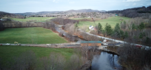
We build near rivers and streams since this is where the roads usually are, as well as the flatter building sites. However, when we build near rivers and streams, we are often putting ourselves at risk of flood damage. We then end up protecting our buildings, roads, and bridges by reinforcing riverbanks or trying to move the river away. This doesn't always work and the river could eventually undermine our protections. But the larger problem is that by trying to control a river, we usually make the water faster, more forceful, and more damaging to riverbanks and structures elsewhere. As the saying goes, "There is no free lunch." Then, structures that were once safe, now need their own protection, passing the problem further down the river and requiring more and more control. It's a vicious cycle and the only way to stop it is to protect the room needed by rivers. Protecting River Corridors where they still function is your cheapest option to protect your roads and buildings that are already near rivers and streams.
River Corridors and Special Flood Hazard Areas are different and require unique considerations. The River Corridor identifies the room that the stream or river channel needs to move from side to side over time, and still remain in equilibrium. The Special Flood Hazard Area often (but not always) extends beyond the River Corridor. This is the area where water may go during a flood. It's important to protect the functions of both of these areas.
No Adverse Impact
This is the most important floodplain management principle. It’s kind of a golden rule for development along rivers: the actions of one property owner should not adversely impact the rights of other property owners. Examples of adverse impacts include increased flooding, erosion, sedimentation, and cost of public services as well as degradation of water quality. No adverse impact is not anti-development, but rather a community-based process to determine appropriate development and mitigation strategies.
In your work to reduce flood risk, you'll likely face cases where what's best for the community is in conflict with a landowner's plan for how to develop their land. The model bylaws provide a framework for development to avoid adverse impacts. Read more about no adverse impact.
 River Corridors
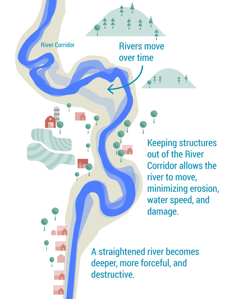
Rivers move over time. They erode soil from a bank here and deposit it there. The River Corridor is the land area adjacent to a river or stream in which the water may eventually move. This area is determined using river science and mapping. It also includes room for a buffer of vegetation to keep banks strong and a margin of safety for nearby structures.
In the diagram, the yellow area represents the River Corridor. Sometimes past positions of the river can be seen with a high resolution shaded relief map such as a hillshade image from lidar. Lidar is very dense topographic information collected by aircraft using lasers. The Flood Ready Atlas has lidar hillshade for most of Vermont. At the bottom of the list of layers, click on "Lidar Hillshade" and click off "Vermont Orthophotos".
 All River Corridors are mapped on the Flood Ready Atlas. Smaller streams may show up as yellow lines with dots. The River Corridor boundary for these streams is fifty feet from the top of the bank.
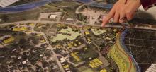
Every town and city should consider adopting a River Corridor Bylaw that will guide new building to safer areas, outside of the River Corrider. This will also help your community qualify for additional funding after a flooding disaster.
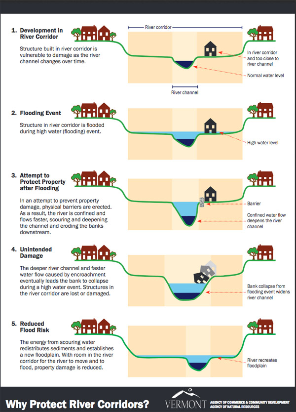
Learn more about River Corridors (on Flood Ready Vermont) • Illustration of problems with building in River Corridors (PDF pictured to the right)
Floodplains or Special Flood Hazard Area (SFHA)
In Vermont, there are over 12,000 structures located in the Special Flood Hazard Area (SFHA). Each one faces at least a 1% chance of flooding each year or a one in four chance of flooding over a thirty year mortgage. This amount of water is referred to as the base flood and the area is mapped as the SFHA. The SFHA was established as part of the National Flood Insurance Program (NFIP) and has regulations that must be enforced by towns and cities in order to remain in the program and allow residents to purchase flood insurance. Anyone applying for a loan for a building within the SFHA must purchase flood insurance.
The SFHA is mapped on the Flood Ready Atlas for about half of Vermont, including Bennington, Chittenden, Rutland, Washington, Windham and Windsor Counties and the communities of Bradford Village, Hardwick, Jay, Montgomery, Newbury, Stowe, and Wolcott. The rest of Vermont will need to rely on paper maps developed by FEMA. These are located in your town offices and/or at the FEMA Map Service Center where you can download PDF copies of paper maps. There are several zones. Zone A does not have an established Base Flood Elevation (BFE) and all other A zones (AE, A1-7, etc) do have a BFE. The BFE is the level the base flood is expected to rise, to the tenth of a foot. It's used to determine how high a structure should be elevated to be safe and what the flood insurance premiums will cost.
Mapping can be tricky and we've assembled more information in our Protection Tools section of this training.
Zone B, C, and X floodplains are outside of the SFHA and are technically less likely to flood. However, these zones are simply estimates and much of Vermont's flood damage occures in these zones.
There are two primary concerns in floodplains:
- When water comes into buildings and causes damage. Buildings should be flood proofed and/or elevated to reduce damage during flooding. We've prepared details for considering the building of an accessory structure in the SFHA.
- Raising the flood level for others: when fill is brought in to elevate a road or building, or when a building is built that does not allow water to pass through it, the floodwater has to go somewhere, causing additional risk for neighboring structures that would have otherwise had a lower flood level.
The NFIP minimum requirements do not adequately protect communities and homeowners. Consider adopting new Flood Hazard Bylaws based on these model bylaws prepared by the Vermont Department of Environmental Conservation.
Learn more about Floodplains (on Flood Ready Vermont)
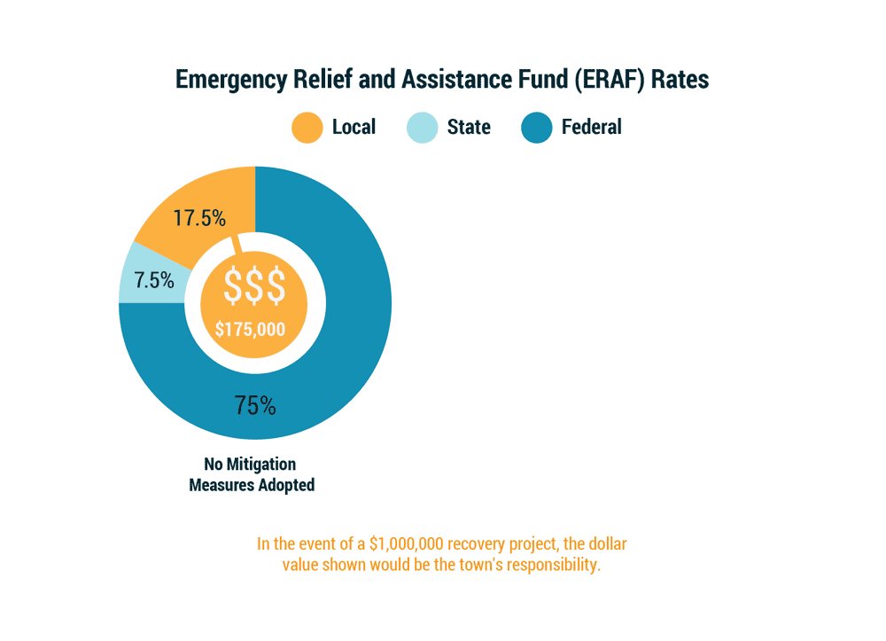
Emergency Relief and Assistance Fund (ERAF)
Flood damage to public roads, bridges, and buildings is often incredibly expensive. For publicly declared disasters, federal and state funding is available to assist with recovery. The amount of funding your town or city will qualify for depends on how effective your plans and bylaws are at protecting your community. Learn more about ERAF and find out the current ERAF level for your community.
Definitions of the terms in the chart above:
- NFIP: National Flood Insurance Program
- LEOP: Local Emergency Operations Plan
- LHMP: Local Hazard Mitigation Plan
- Road & Bridge Standards
- River Corridor Protection

Reflection Questions
- What else does your municipality regulate for public safety and no adverse impact?
- When you look at your community on the Flood Ready Atlas, which vulnerable roads, critical facilities and settlements are within the SFHA and River Corridor? What can you do to protect them now?
- When was the last time your community updated your flood hazard area regulations? Do the standards meet the NFIP requirements? (If not, or if you're unsure, discuss with your Regional Floodplain Manager.)
- Are you aware of places where riverbanks have been armored? If so, how has the channel adjusted downstream?
- If the Town had a public damage bill of $1,000,000, could your budget cover it? What level of ERAF funding do you qualify for now? What can you do to be sure you have the resources to recover quickly after a disaster?