Montgomery At A Glance
Population: 1,201
Location: Franklin County
Rivers: Trout River
Flooding: Devastating flash flood in 1997
Actions: Updated Town Plan and Zoning Bylaws
Story
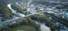
 The memories of the 1997 flood are still fresh for many residents of Montgomery. In the early hours of July 15th, a devastating flash flood turned the Trout River into a torrent, destroying roads and bridges and inundating the community with water. “A lot of folks in town remember standing on one side of Main Street and looking at the other and saying, ‘I can’t get there - there’s a river in the way.’” reflected Montgomery resident Charlie Hancock. “So those things really do stick with members of the community and influence their recognition of the potential problem and their willingness to address it through planning and zoning.”
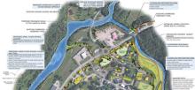
Charlie served on the Montgomery Planning Commission while they recently updated the Town Plan and on the Selectboard when new Zoning Bylaws were approved. Both the plan and bylaws incorporate ideas of smart growth to ensure the village continues to grow and prosper while conserving important natural features and reducing flood risk. During this planning process, Charlie turned to the Vermont Rivers Program to explore options for river corridor management. The river scientists and floodplain managers from the Vermont Department of Environmental Conservation brought a variety of mapping tools to the community. In particular, maps created using lidar – an aerial surveying method using laser pulses to scan a three-dimensional model of the landscape – proved very useful in Montgomery. “The lidar maps specifically were crucial in our process,” said Charlie, “because looking at the bare earth picture you can see where the river has been in the past, where it is now, and then where it’s probably going to move in the future.” In many places a lidar hillshade image is available on the Flood Ready Atlas. Click on the "Lidar Hillshade" at the bottom of the Layers and click off the "Vermont Orthophotos".
Having adopted zoning bylaws that incorporate river corridors, Montgomery in now eligible for more Emergency Relief Assistance Funding (ERAF) from the State of Vermont. But for Charlie, this planning process has been about more than just money. “More importantly, I think, it’s the idea that if we limit the development within these areas, we’re going to limit the potential damage to somebody’s home and we’re going to limit the potential to put some of our first responders at risk.”
The 6.5-minute video case study on Montgomery includes the following voices:
- Charlie Hancock, Montgomery Selectboard
- Scott Perry, Montgomery Historical Society
- Rebecca Pfeiffer, Vermont Department of Environmental Conservation
- Staci Pomeroy, Vermont Department of Environmental Conservation
Montgomery's Lidar Map


Reflection Questions
- What is the flooding history in your community? How high has water risen before?
- Where have your rivers and streams traveled previously and where might they move to again?
- What maps and elevation studies are available at your town offices?
- What would following no adverse impact guide development in your town or city?
- What land currently acts as flood storage or is available for a river to move into? Is it at risk of being filled or developed in a way that would remove that service?